A place holder for tookiebuntendotcom. My main blog is over at http://tookiebunten.com or http://walkwithtookie.com
Thursday, 31 March 2011

Tuesday, 22 March 2011
How lofty, sweet Afton, thy neighbouring hills
"How lofty, sweet Afton, thy neighbouring hills, Far mark'd with the courses of clear winding rills;"
It is strange how some things happen. Without realising a course is set and at the time you don't even realise. A few weeks back Mark Roberts (@bckpckingNorth on twitter) tweeted a link to post about an over night walk he had gone on, up the Afton. Mark lives in North America. I had replied, asking him if a Scotsman or a Robert Burns fan had named the place? For those of you that don't know I'm an Ayrshireman and grew up in Cumnock not 6 miles from Glen Afton, an area of wild country on the edge of the Southern Uplands. Known by many throughout the world from Burn's song Flow Gently, Sweet Afton. Unknown to me or to Mark at that time he had planted a seed.
Fast forward a couple of weeks and I had made plans to visit my parents. I hadn't given them a time of arrival, other than I would be down to see them. Yes, I would be there for dinner. Off I went. Heading for Cumnock. It's roughly an hour travelling time in the car from where I live now, East Kilbride. I got to Auchinleck and took the by-pass for Cumnock but instead of taking the exit for Cumnock at the next round about I continued on the rest of the by-pass for New Cumnock. I've got into that habit of carrying my basic kit in the boot of the car. Hoping for a chance like this, spur of the moment. I had time, the weather was dry but overcast. I didn't look like it was going to rain. The seed had sprouted. Glen Afton here I come.
Maybe I should probably point out Cumnock is actually Old Cumnock but is younger than New Cumnock? Still following me? At one point there was just Cumnock. A loose connection of ferm touns, tower houses and of course the church. Then in 1650 it was split into two parishes. Old Cumnock where the original church stood and New Cumnock where, yep you guessed it a new parish church was built. Doesn't make much sense but we've got loads of history that gets ignored in the books and it's not just all about Robert Burns. Wallace and The Bruce wandered here, hiding from or terrorising the English and there's more besides.
Anyway I'm on the road to New Cumnock. Passing the place I got married. In and out of New Cumnock and on to the road up Glen Afton. It's not a place to linger anymore. New Cumnock has turned into an empty, sad and desolate shell. Nearly everything in the main street is boarded up and closed. The church is smashed. The whole place is dejected. An air of loss. It is place of no hope or so it seems as you drive through. It's missing a heart and a soul. A ghost town. The pits have gone and all the industries that went with it. They've been gone along time and now it appears to be taking it's toll. The reaper has moved in. No jobs, no money. A sign of the times. Old Cumnock is fairing much better.
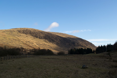
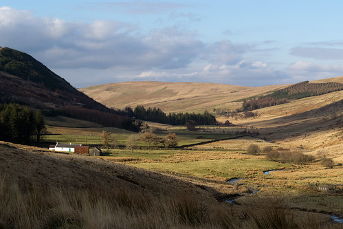
Passing by the Robert Burns memorial and the Glen Afton Caravan Park. It's single track road here with plenty of pot holes to swallow up your car. Lots of weaving and hoping that you don't meet another car. The passing places are few and far between. There's a dam at the head of glen now. I say that like it's something new. It's been there since the 30's and it has a car pack that you can use. That was my target. Park there and wander round the loch that has been created there. Spend some time in the 'ruins' of castle William, sitting on the Cloven Stone at Blackhill. Maybe round to the ruins at Montraw, now encased in trees. For some reason I pulled up short. A couple of miles short of the dam at Blackcraig Farm. I had a sudden urge to climb my old friend Blackcraig, the highest hill in Ayrshire. It had been a while. The farm has had new coat of paint since the last time. The only obvious indication that time has passed.
There was no-one else about that I could see but I still got changed behind the car door. This is turning into a habit. I headed up the road to the farm and skirted by the buildings and the little wood that forms a wind break around it to the beginning of an old road. Not a drovers road but an old cart road. It looks like that to me but I don't know for sure. I do know that it'll take you over the hills to Kirkconnell. It feels great to be walking here again. The weather was clearing; the clouds where getting patchier, sometimes the sun was poking through and catching the still dormant heather and grass. The hills looked golden in places. When the clouds parted the sky was blue and bright. Which means it wasn't raining, always a plus for the west of Scotland. In my head the plan had evolved from walking round Glen Afton and the loch to climbing up Blackcraig, was now sprouting arms and legs. I was starting to think; Blackcraig, Greenlorg, Blacklorg, down to the dam and back to the car. A favourite of old. A great walk.
My mind set and my route locked. I tightened the straps on my rucksack and continued on the old road. I love walking these forgotten ways. It feels to me like you've been let in on a secret that no-one else knows. Following a faint and over grown trail that's long since slipped from the world's conciseness. That you are standing in the footsteps of old, ancient people and if listen hard enough you can here the rustle of feet and clip clop of the hooves from the ghost's of the past. As the old road climbs following along side the Langlee Burn until it peters out. You cross over many rills, nameless springs and small burns that litter the hillsides of this glen. Flowing down to meet the sweet Afton and onwards to the river Nith and the sea at the Solway Firth.
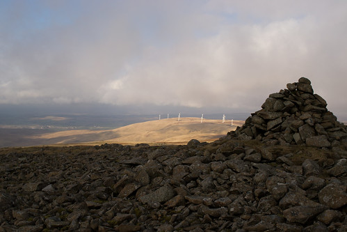
It's not long before you feel like you are in the wilds here. There are now some intrusions into this with three wind farms that surround the the Afton. Hare Hill, McCrierick's Cairn and over the other side at Windy Standard. Men have always been in this landscape so are the turbines and more of an encroachment? Is it not just another way of announcing our presence here? Instead of cutting down trees or removing coal and peat, creating false forest we're planting great metal monuments to the power of the wind. It is scar on the landscape but no greater or worse that I have seen here. Whole hillsides removed and altered for the want of coal to power our lives. They may take away from the view but they also add something to it. Almost monolithic like standing stones of old. Sentinels watching over the hills, an army in waiting. However here, they don't take away completely the feeling of isolation and wildness. There are no longer any of the old sheilings up this high. Just the ruins and the sheep. The farmers only come up to gather the sheep in for winter and lambing. No one lives and works up here. Trying to scratch a living. They are all long gone. No one lives here.
I was to all intent and purposes on my own. A lonely walker but not feeling alone. I have history here. It is the land of my fathers. Born, raised and steeped in this very place. Places that are mine, where I belong. This is home. A poem by Sir Alexander Gray and strangely not Ayrshire's most famous son comes to mind.
"This is my country
The land that begat me.
These windy spaces
Are surely my own.
And those who here toil
In the sweat of their faces
Are flesh of my flesh
And bone of my bone."
The land belonged to me, there was nobody else to dispute the claim. Ayrshire was my kingdom. For all the soul-less and down at heel towns that Ayrshire has, it has these glorious wide open areas of magnificent beauty but I am biased and I fear a rant but I will spare you that.
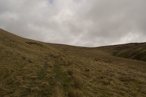
Back on the road it appears that someone. Some national body is trying to open them up. Make it accessible. I'm all for that. Following the rutted old road ever upwards, ever higher. Marker posts have been put in place indicating a right of way, a walk to some place. These are new to me and I'm excited about this but also a little sad. Sad because if you know what to look for the markers are already there. Larger stones marking the edge of the road, larger stones again marking where the road turns but that too is obvious as it follows the contour of Laglass Hill. Most obvious of all, the cairns on the knowes. Stark against the horizon; shouting, this is the way. Maybe others are discovering what I already know and maybe they need it pointed out a little clearer. I've climbed to the top of the pass, stopping to touch each cairn. Thank you, you have led the way.
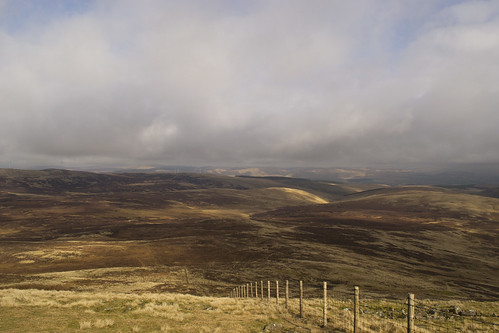
Galloway, an other old haunt is in front of me, Ayrshire ends not far from this spot. The Southern Uplands are rolling away in all directions as I stand on Quintin Knowe. No man's land or the disputed land if you like. Depends on how you want to translate the corrupted Gaelic, much like Hare Hill to my left. There's a wooden post here to, but for me it's not pointing the right way. It's pointing off to the summit of Blackcraig. Not my way, not yet. It wasn't where I was shown all those years ago. To me this is leading you the wrong way. Taking you an unnecessary and steep path to the top. I continue on the road for a bit. Why make it hard if you don't have to? There's a gate and a fence where once there was a dry staine dyke that runs over the top. That's where I turn for the top following the fence. The old ways die hard, you go with what you know.
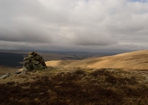
There are fresh foot prints in front of me where the track has worn through to the peat. Not by the feet of man, the sheep also walk this way. Somebody else know the secrets. More likely anither local. Ayrshire to my right and Galloway to my left is I climb up the shoulder. There's more cairns on the top, three in total and then there's the trig pillar. I zig-zag my way across the large flat top to the first false summit to touch the cairn then I make my way back to the fence and the stile to carry on to-ing and fro-ing between the cairns to the top. Dodging the boggy bits until I get to the trig point. The clouds have blown in. It seems to be my lot. Clouds obscuring my views. They blew in when I touched the first cairn. Bringing the quiet peacefulness with them, expanding distance and compressing time but unlike Tinto I've been here on countless occasions. I know where I am. No doubts creeping into my head here.
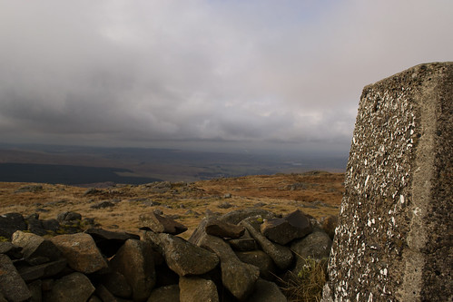
I have arrived. I get squated down into the wind break at the pillar. On with the insulating layer as it's cold in the cloud and the wind now that I've stopped. Brew time. This time I don't have to worry about a solid brick of a chocolate bar, it wasn't that cold. Cold enough though. I have great view to home now that the cloud is moving off again. There is still a ceiling of the fluffy stuff but it's now higher than the two and half thousand feet that I'm sitting at. Ayrshire is spread before me like a large patch work blanket of earthy tones. Nothing is green yet, except for the pine forests and a few of the grazing fields. Even then their green is dulled by winters grip. The signs of spring are still few. Every now and then your blessed by a small explosion of snow drops or sprouting daffodils not quite come to flower. Everything else I see from my seat on top of the world is tones of yellow and brown. Patiently waiting for the suns warm spring caress rather than this cold and unloving winter glimpse that it gives just now.
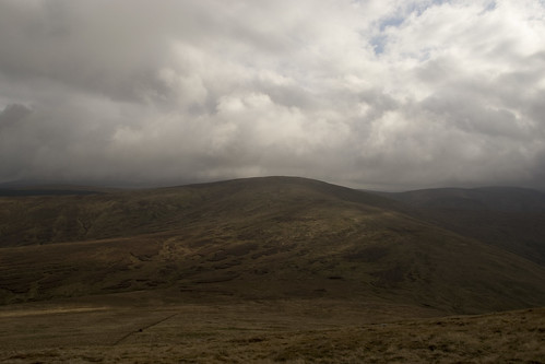
Packed up and ready to continue. It's still a bit chilly so I keep on my insulated jacket. I make my way over another stile down the other side of Blackcraig making for Greenlorg Hill. Blacklorg Hill off in the background and little higher again. Here I can see Cairnsmore of Carsphairn in the distance. Another hill that I haven't stood on for a long time. The cloud hanging on his head. You can walk all the way to Cairnsmore but that's a longer walk and one for another day when I've better planned things. As usual, I'm not far off the top and the sun comes out. The clouds float way leaving large swathes of bright blue sky. No need to be insulated now. It feels warm in the sun when the wind is no longer blowing at my back. Off with the rucksack and I deposit my jacket in there and get the sack hitched back up. It's steep and no natural path or track as such. Follow the sheep, the fence or make your best guess. I opt for the yowes. They aren't as daft as they make out, especially in the high places. They can read contours better than I can.
Having followed the track down onto the bealach. It was time to climb up and on to Greenlorg Hill, which I find a bit strange as it's not much of a hill on its own. Before; back in the mists of time, there was just Lorg hill, Slope hill. Now we have Greenlorg the green slope that leads onto the Black slope, Blacklorg. Lorg meaning slope. It's not the only one to change. Over the other side of Blacklorg stands Meikledodd Hill; big hill hill, was once Montraw Hill, the boundary hill. Monadh being hill and airbhe meaning boundary. Again it depends on your translation of the corruption. There is still a burn by that name and an old ruined farm with that name too.
Looking up to where I was heading I was suddenly aware of movement. Just a flash. Something quick. I stopped and looked. Looked hard. You know that way where you screw up your nose and focus. I'm moving my head left to right and back. Working across the hill. I was positive something was out there, I began to think that maybe it was just the sun catching the hillside. A beam poking out lightening fast as the clouds move. Fleeting. Then I see it again, this time I'm locked in on it. A Roe deer flashes it's white erse at me. Not deliberately, I don't think. It's a small group. Three in total, two females and a young buck. Not much in the way of antlers. I haven't been spotted yet and the wind is blowing my scent away across the glen. The fawn coats melding them into the long tussocky grass perfectly. Perfectly, until they turn away from me and face up hill. I can see the whites, well not of their eyes.
I would love to get a good photograph but I don't have a long lens. Haven't got the money for that, yet. I only have my kit lens. A 18 mm to 55 mm. I'm going to have to get closer. Much closer. The deer hold the high ground. I can't get above them without them catching my scent. The stalk is on. Slowly and painstakingly I make my way down hill. They haven't caught sight of me yet. I keep checking. Furitive glances up hill. White bums bobbing. I drop down a few contours and I'm completely hidden from them as they are for me. Guess work now, how far I should walk along this contour before moving back up. I'm trying to judge my pace with they're movements. Tyring not make any sudden and unusual noises. Hoping I don't clink the walking poles together, hoping that any noise I do make is carried a way on the four winds.
I'm close. I can feel it. The alarm in my head is ringing. It's time to start moving up hill. I stab the poles into the ground and place my rucksack at the base of the two walking sticks. Down on my honches, I start a crouching walk up to the crest of the contour. I can't hear them but I know the deer are over there. Not two feet from the false summit I get down on my belly. I'm now crawling, slithering forward inch by inch like a snake. I'm there, the deer are there. We're all there. I can't get the camera round. Off like the green light had come down on a formula one start. I was too close. Not six feet from them. The deer had changed direction and moved downhill towards me. They must have changed direction when we couldn't see each other. I have never been that close to deer. Never. Playing it back in my mind it was slow motion stuff like a John Woo movie minus the white doves but still so fast. Incredibly fast. The nostrils flared and the deer turned tail and made light work of running in the long grass. Up and over Greenlorg in no time at all. I turned over and lay on my back looking at the blue sky and watching the clouds run over head. Thinking a longer lens might be the better answer.
The deer were gone and I had no chance of following them any further and no photographs to boot. To top it right off and stick some icing on the cake, I found myself trapped behind a new deer fence. More trees must be getting planted soon. FUCK. How did I manage to be on this side, the wrong side. I never saw the fence from up on the shoulder of Greenlorg. Too busy focusing on the deer. FUCK. Stupid. Much cursing of my own name. I'm not sure if your familiar with deer fencing but climbing over it where I stood was not an option. Therevery flimsy. There not meant to climbed over and I can guarantee there was no stile along it's length. I was well off the beaten track, so far in fact I was probably on another reservation. Off piste walking and deer stalking are us dot com. The high of the chase and low of the let down.
There's a lesson to be learnt. Somewhere. I'm lucky I know the lie of the land so being stuck here was not a problem. The problem was getting over the other side of the brand spanking new deer fence. I suppose I could have returned in the direction I had come from and try to find where the fence had started but I was closer to the road on this side. I followed the dyke round to the upper reaches of the Craig burn and found a turn in the fence where it headed down the other side of the water. A right angle. Ideal. The large corner post would more than take my weight and the wire was tighter here. I passed my poles through the fence and tossed my ruck sack over. I climbed the fence. No fancy commando rolls over the top wire. Didn't want to injure myself. I had been silly enough today already. The plan had changed again. I don't have the time to gain the height and head over Craigbraneoch Hill to catch the path round the dam and back to the car. I'll make for the road best as I can from this side.
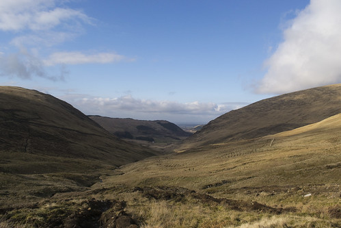
Now I was on the correct side of the fence, skirting round the side of Craigbraneoch. Next obstacle was getting to the other side of the Craig burn. That wasn't difficult, in these upper reaches it's nothing more that a rill. I was having more difficulty with the massive ditches that have been scored into the hillside to drain the peaty soil and make the rigs for the trees to be planted. It was the good old short ass, legs not long enough problem. I stopped for a few minutes to get my breath back after all the pole vaulting I've been doing with my walking sticks. I looked down towards Afton Glen, the sun now on it's downward arc casting large shadows on my side of the glen. The sky is a crisp, sharp blue and the view down the Afton is superb. I also notice further above me that the rigs change direction and start to run top left to bottom right in a more or less horizontal fashion. A unexpected turn of luck. It's the way I want to be heading. I scramble up and jump across my last ditch. The rig is getting wider and wider when it becomes a very new scar in the hill. A new forestry road, hard packed with stone and I can see it leads all the way to Craig Farm. Craig Farm leads to the road and the road leads back to the car. Only a couple of miles of road walking. It was pleasant walk back to the car with my thoughts turning to visiting my parents and dinner. A fine end to a great day.
Saturday, 19 March 2011


Thursday, 17 March 2011

Saturday, 12 March 2011

Wednesday, 9 March 2011
And in that kist, there is.....
I needed a walk but where to go? I didn't want to travel too far, I wanted to gain some height however I didn't want to go to any of the usual suspects in my area, west central Scotland. Somewhere new. Hmmmm. Then it came to me, Tinto! I've lived in East Kilbride for 7 years now and it's somehow taken me this long to get round to Tinto, Tinto hill. It's one of those I keep meaning to do but then I forget about, something else pops into my head and then the thought is gone. I'm off walking somewhere else or doing something else. This time though I was going. I had nothing to stop me and no excuses. The latest OS map was in my hand, courtesay of my good wife. All that was left to do? Go see the cairn and stand on the highest hill in Lanarkshire.
Down the M74 I bombed, so much so I missed the Douglas road end. My excuse, it looks different travelling north to south than my usual west to east along the A70. It didn't matter much, I took the next exit at the Abington services and worked my way back on the A702 and back onto the A73. After a bit I took the junction for the A72 and Thankerton. For most of this leg I could see the massive hulk of Tinto. I know that it's only 2333ft but because it stands proud and on it's own, it looks massive. There's nothing next to it to dwarf it or to give you a perspective. It's there in the landscape, shouting hello. It was looking good, sprinkled with fresh snow but clear to the top. From the car it looked almost perfect. Finally after the extra miles, I pulled into an empty car park. It was still early not much after 8:15 am. Excellent. The skies were still clear. I got changed behind the car door, retrieved my Alpkit rucksack from the boot and started off up the path.
There's a couple of different ways to the top of Tinto and this one is probably the most popular. The path is rather straight up and down according to the map. It's a well used path, probably for a couple of thousand years judging by the width and how it bites into the hillside. It's not hard to believe either, as the cairn at the top has bronze age beginnings. You also have the pleasure of walking in a well preserved hill fort just off the main path on the slopes of Totherin Hill. You can imagine the residents of the fort marching up the path to the cairn to light the fire on Beltane. It's also a favourite of those nutters, the hill runners and apparently paragliders.
About half a mile from the car park; the Hill fort becomes visible, the large rings and ditches. I spent some time walking round the ditches wondering what it would have looked like. The defences must have been really big as even now at some points I was disappearing from sight in the ditches. I think that there would not be much more than a couple of buildings inside. As the diameter is not more than 60 odd of my strides, across the inner most circle. More a job for the Time Team than my uneducated guesses.
I got my contemplative self back on the path and started on the first hurdle. Up and over Totherin Hill. It's a nice lung buster for this little unfit walker to stretch his legs on. I made steady but slow progress. Not that it mattered. I was walking with myself and having fun. I stopped often; to take photographs, not catch my breath. If you hear anything to contrary, lies. It was windy but fresh but not that I needed any extra layers on when I was walking. I had built up a good head of steam. The views that I was afforded to the south and west were great. I could see far down the rest of the Southern Uplands into Galloway and Ayrshire. I could even make out the Kames at Muirkirk and it's flat table top summit. Beautiful. Even although there was still no sign of spring. The heather still brown and sleeping, waiting for a warmer sun and less frost.
Tinto's tap had been hidden for a while and as I got over the top of Totherin Hill, I was surprised to see some really heavy looking clouds had blown in. Angry looking fuckers with menace attached also know as snow carriers. You know the type. Not what I was expecting it but not unexpected. It's Scotland in February. As a reached Maurice's Cleuch and started to climb upwards again the cloud started to drop the white stuff. Nothing drastic, a powdering like it was covering a cake in icing sugar. The visibility was getting shorter with every step but not to a degree that was I going to worry and especially not on this hill.
I always find that when the clouds close in around and envelope you an eerie quiet descends with them. Very peaceful except for the crunch my foot falls on the gravel and the clink of the tungsten tips of my walking poles. It changes your perspective and distances expand as your vision shortens. The path was getting harder to pick out with fresh snow falling even although it was light. It was adding to what was already there. I was having to look hard for the depression in the ground that indicated where the track was. I just took my time and every now and then I would see a frozen foot print in the snow. Visibility was down to less than twenty feet by now. At that point the fence appeared that isn't shown on the map. It would lead me to the summit. That made things very easy, I just had to keep the fence on my right and it would take me all the way.
Enjoying the solitude and the quietness. Just me, my thoughts and the hill. Enjoying the placing of one foot in front of the other. Making my way slowly to the top. Completely absorbed in my little world. Until...... SQUAWK! I disturbed a grouse. I jumped out my skin with the sound of it's unholy scared calling. The bird took flight. Frantic flapping. Disappearing into the cloud and snow. Not sure who got the bigger shock but I'm certain it's final call as it vanished was calling me a tnuk. Sounded very much like it. A bastarding grouse! I'm jumping about like one of those blood thirsty pterodactyls from the land that time forgot was about to swoop down and carry me to my doom. I had a word with myself, popped my heart back in my mouth and got on with following the fence. Luckily I was walking solo.
I was beginning to feel like I was walking to the ends of the earth, that I should be on the cairn by now. I was even tempted to dig the map out but I knew it was my mind playing tricks in the cloud. Not sure what I was going to take a reading from, there was nothing to get a bearing off. I suppose I could have juiced the battery on my iPhone if I really needed to but then that's dependant on a signal. I knew hadn't walked nearly as far as I had sensed. Plus the fence hadn't changed direction yet, it's not marked on the map but it takes an angled turn when it reaches the cairn and the trig pillar.
Shaking the clouds from between my ears I continued on. All of a sudden out of the gloomy clouds appeared THE cairn. I've seen some big cairns in my life but nothing like this. It's massive. There at that moment in that weather it just towered above me. Not that that's hard and here was me, minutes earlier thinking that I could have walked by it. I never measured it but the cairn is six metres high and about forty metres across and that's how it stands just now with the top loped off it. Would be interesting to see in all it's glory before it collaspsed and some folk building wind breaks from the stones. I was a bit exposed to the elements standing on the top. Techinically the highest point but not really, the trig pillar was off to my left and a little hidden in the clouds. I sclimbed down and louped the dyke, walked over and touched the trig point. Done. Summit reached. Not that I was bagging the summit. I just have the urge to always touch the pillar like I do with cairns. I just have to physically touch them and connect to them. I suppose it's my little ritual.
I jumped back over the fence and hunkered down in the lee of the large summit, out of reach of the wind and whispy blowing snow. Brew time. A Lion Bar and a cup of tea. Out came my Pocket Rocket, behave! Stop the sniggering at the back there. Yes that means you. I got it fired up, poured water into my Halulite Mininalist pot and got it on for the boil. The Lion bar was solid, like I had left chocolate in the fridge over night. I wasn't expecting that. I got as comfy as I could. The water boiled in no time at all. Hoping that the wind would carry the clouds away and that I would at least get a break so I could snap some photographs of the view. Dunking your Lion bar in your tea makes for an interesting cuppa but it certainly softened the bar.
I gave up. The cloud wasn't for clearing anytime soon and I could see ice was starting to form on the Gourdon where the sweat collected on the backpack. I gathered my gear back together which is to say I tidied up my stove and the pot. I started to follow the fence and my fresh tracks back down. It wasn't long till I was scaring the grouse again. This time I was ready for the blood thirsty pterodactyl. No fright this time. After that I was out the cloud and looking down on to Totherin Hill again and I could see the views again. Much to my surprise I could see two people making their way up.
I past the two, a man and women. We spoke, just a short conversation. Pleasantries. Me passing on the summit conditions. I had not long left the couple when I spotted another next walker. In fact it was probably only a couple of minutes. An old guy out for a walk. Hopefully I'll still be fit enough at his age to be tackling nice strenuous walks like this. It was starting to get busy. After him it was like a slow procession; a guy, 2 guys, a guy with 2 dugs, guy with a big Clydesdale cuddy o' a dug. A great Dane I think, It wasn't shaggy like a Lurcher but smooth like a Setter. I'm not up on big breeds of dug. Whatever it was; it could probably bring down a deer, the way it was loupin' aroon the dormant heather. It didn't have a leash, it has reigns. FFS. It could definitely pull a plough. It was big enough to walk up to me a gie my dish a lickin' without standing on it's hind legs. If it did that it would be taller than me. Easy.
Then I was back at the Fort heading to the car park thinking that it was going to be a busy lunchtime on the tap of Tinto. On Tintock tap, there is a mist, and in that mist, there is a kist, and in that kist, there is a cup, and in that cup, there is a drap. Tak' up that cup, and drink that drap, that's in yon kist, on Tintock tap. Expect there was none of that but I still had a good time.
Monday, 7 March 2011
GSI Outdoors Halulite Minimalist
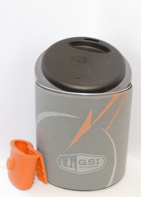
Next on my list was a cook set in my continued search to lighten my back backing load and not spending a fortune. I have this two pot set where the lid was a frying pan. It was heavy but I could fit the gas canister and MSR Pocket Rocket inside with ease. However it was an unwieldy size and weight. I was looking at the titanium sets that were available and weighing up my options *groan*. There were the usual suspects; MSR Titan Kettle, Tibetan Titanium series, Vargo Tri-lite. In the end it came down to some economics and price. I had narrowed it down to a choice of three; Alpkit's MytiMug, GSi Outdoor's Halulite Minimalist and the Tibetan Titanium 450 mug. All were priced around the £25 mark. After a bit of Eeny, meeny, miny, moe, catch the baby by the toe. If it screams let her go, eeny, meeny, miny, moe, you are it. I went for the Halulite Minimalist.
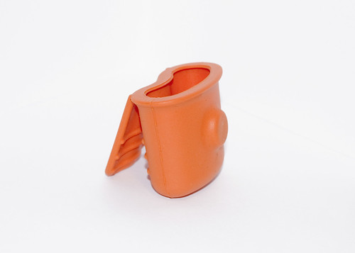
Why? I just felt I was getting more for my money. The Tibetan is just the mug, the MytiMug comes with a lid but the Halulite Minimalist comes with a lid, an insulating pot sleeve, a foon (their version of a foldable spork) and a silicon pot gripper.

It's made from Halulite a proprietary alloy that is hard anodised. The blurb on the website claims; it's as light as titanium, resistant to scratches, abrasions and burn circles. The alloy is uncoated therefore eliminating the need to use special utensils to protect the pot. All this to help keep the weight down and the thermal efficiency up. I can't say it boils any quicker or slower than any other pot. I haven't set up any tests to time the boil. It doesn't leave me hanging about for a brew and there are no; as of now, scratches from my titanium spork. It's build quality is very good.
On my scales it weighs 99 grams naked. That's without the sleeve, lid and pot gripper. With them it's 173 grams. It's a neat little package with diameter of 100mm and a height of 105mm by my ruler and holding over 600 millilitres. Big enough to hold a Coleman 100 or similar sized self sealing gas canister and even a small canister top stove like the Optimus Crux for carrying in one convenient package. Unfortunately not my Pocket Rocket.
I'm glad that I fired up the stove and tried the pot out before going on an actual trip with it. I found a couple of issues. One being the silicon gripper. I found that if I filled the pot full of water and then tried to lift the pot off the stove with the gripper, my two fingers were in the boiling water. Although they were inside the silicon you could still feel the scolding heat from the water. Also I felt that it wasn't secure having to lift 600ml, 600g of water plus the weight of the pot between your thumb, index and middle finger. I don't have the finger strength of a climber and I don't want to have to go and do some Kung Fu 5 finger death punch exercises in order to lift it. I resorted to using my buff as I have done frequently in the past with other vessels but I could have used the pliers on my Leatherman or a set of pot grips.
The 0.6cl is plenty of water for a good big cuppa tea and this is the crux if you're like me and aren't that keen on dehydrated meals. This is your one pot for cooking and drinking from. Do yo take the weight penalty and carry a cup for drinking your beverage out of? I'm tying to shave the weight off not add more. As of the last few times I've used it, I've just cleaned it out. Not very efficient. I reckon that if I could get a taste for dehydrated meals I would have more than enough water for a meal and a drink in one boiling. No need for repeated cleaning then.
My other issue was with the folding foon. I broke it, at it's folding joint but this could just be me. I can be a bit heavy handed when it comes to utensils. I have managed to break or melt three of the 'indestructable' plastic sporks made by Light my Fire. I now have a titanium one and it seems to handle the abuse that I dish out, at the moment. It was light and would do the job shovelling your grub but I didn't get that far with it.

The lid and neoprene sleeve are great. The insulating sleeve does what it says, allowing you to hold the pot with out the fear of burning yourself or get dirty and it's great for keeping your brew warmer longer. Especially on the cold mornings around camp. The lid is a very smart design as well; flip it one way and it is a standard lid helping to get the water boiling quicker, flip it the other way and it becomes one of those Starbucks like sip it lids.
I know in the one hand this won't be the pot for everyone. I on the other hand really like it. It works for me with how I'm walking and camping. I'm happy with it.


